Aerial Pins for 360° Drone Photos: Callout Hotspots in PanoCool
Pin schools, parks and train stations on a 360° drone photo, outline the lot and export marketing images, all in PanoCool.
What are aerial pins?
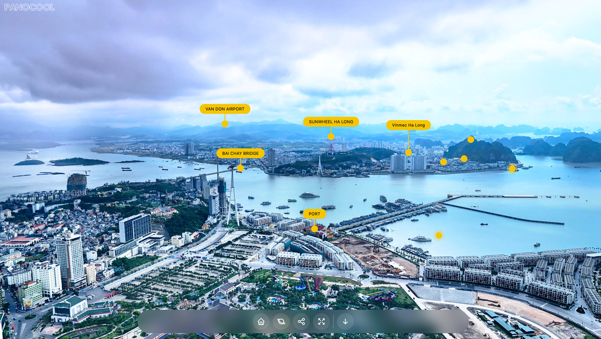
Aerial pins are labeled markers on a drone photo that point to the places buyers care about near a property: schools, parks, shopping centers, train stations and cafés. Each pin usually carries a name and a distance, such as Riverside Primary School · 0.7 km.
Real estate drone photographers add them to property marketing images because one picture answers "what's nearby?" faster than a paragraph of listing copy. Add a property boundary and the lot size, and the buyer sees the home, the land and the neighborhood in a single frame.
In PanoCool, aerial pins are callout hotspots: a dot, a line and a label. The difference is where they live. Instead of a flat drone photo, you pin places on a 360° aerial panorama, so buyers can turn the view and find every pin in place, and you can still export flat marketing images from it.
Why pin nearby places on a 360 drone photo
A flat drone photo shows one direction, so you choose which amenities make the cut. A 360° aerial panorama, shot from one spot above the property, shows every direction at once. Most camera drones can shoot one with a sphere panorama mode.
- Every amenity in one image. The school behind the house and the park in front can both be pinned, wherever they sit around the lot.
- Pins stay on their landmark. A pin is attached to the panorama, so it stays on the school roof as the buyer turns or zooms.
- Labels open as you look. A callout label pops out when its pin nears the center of the screen, which keeps a view with ten pins readable.
- One flight, many images. Export a square image for Instagram, a wide one for the listing portal and a story for Facebook from the same panorama.
- Part of the full tour. The aerial scene can sit next to your interior 360° scenes, and a pin can take the buyer straight into a ground-level 360° of the backyard or the street.
What you can build with callout hotspots
Everything on a typical aerial marketing image has a matching tool in the PanoCool editor.
On the image | How to make it in PanoCool |
|---|---|
Pins for schools, parks, shops and stations | Callout hotspot: a dot, a line and a label |
Place name and distance on each pin | The callout text, up to 250 characters over several lines |
A photo or icon inside the label | A linked scene thumbnail, your own image, or one of 100,000+ icons |
Pins in your brand colors | Theme colors, ready-made palettes, or custom dot, line, background and text colors |
Label shape and finish | Box corners, padding, background blur, border and line opacity |
The same pin style on every listing | A saved callout preset (Cool and Super Cool plans) |
Property boundary | Polygon hotspot with your own border and fill color |
Lot size and frontage, such as 450 m² or 14 m | Text hotspots placed along the boundary |
Something to click | A pin can open a popup, a photo gallery, a link or another scene |
A still image for the listing | Download photo → Reframed photo, with hotspots drawn in |
Retouching | PanoCool Retouch: AI object removal and enhancement |
You type each place name and distance yourself (Google Maps gives both), then drag the pin onto the landmark. Because you see the landmark in the 360° view, the pin lands exactly on it.
How to add aerial pins to a 360° drone photo
1. Upload the drone panorama
- Shoot a sphere panorama with your drone, 40–100 m above the property, high enough to see the nearby landmarks.
- Open the PanoCool editor and create a tour from the 360° photo. JPEG files up to 32,000 px wide and 300 MB are supported.
2. Add a pin for each nearby place
- Open the Elements tab and click Callout. The pin appears in the middle of the view.
- Drag it onto the landmark: the school roof, the station platform, the shopping center car park.
- In the hotspot toolbar, click Change appearances.
- Type the label, for example
Riverside Primary School · 0.7 km. - Set Line height to lift the label above the rooftops. Give neighboring pins different heights so their labels don't overlap.
- Under Display image, pick Icon for a school, train or shopping cart icon, Custom image for a logo, or switch the image off for a text-only label.
- Under Colors, pick a palette or Custom and set the dot, line, background and text colors.
- Click Save.
3. Reuse the style
Click the bookmark icon next to Save to store the style as a preset, and mark it as the default. Every new callout then starts in your colors. Saved presets are also listed in the Library tab under Presets. Presets need the Cool or Super Cool plan; the callout hotspot guide covers every style setting.
4. Outline the property boundary
- Open the Elements tab and click Polygon.
- Hold Shift and click each corner of the lot, then click Save.
- Click the polygon, then Polygon Appearances, and set the border and fill color and opacity. A white border with a 10–20% fill reads well on most roofs and lawns.
A short video on polygon hotspots shows the clicks.
5. Add the lot size and frontage
Add a Text hotspot from the Elements tab for each measurement, such as 14 m along the frontage and 450 m² in the middle of the lot. Use Stitched mode so the numbers stay fixed to the panorama and scale with the boundary when the buyer zooms.
Tips for real estate drone photos
- Pin 5 to 8 places. Pick what buyers of that home ask about: schools, the nearest train station, a shopping center, parks and playgrounds, the beach or the city center.
- Use one kind of distance. Straight-line or driving distance, rounded to 0.1 km, and the same kind on every pin.
- Keep labels short. Name and distance fit on one line on a phone. Put opening hours or school zones in a popup that opens when the pin is clicked.
- Use the same icon for the same kind of place. A cap for schools, a train for stations, a tree for parks. Buyers learn the legend in a second.
- Choose contrast over style. A solid orange or navy label with white text stays readable against sky, roofs and grass.
- Show every label at once. Set Pop-out area to 0% and each label stays open whenever its pin is on screen, like a printed aerial map. Raise it to open labels only near the center.
- Hide far pins until the buyer zooms in. Open Visibility in the hotspot toolbar and choose Show at certain zoom levels.
- Link the pins. A pin on the backyard can open the backyard 360° scene, and a school pin can open the school's website.
Share the tour and export marketing images
Put the 360° aerial on the listing
Open Share to copy the tour link for the listing, your agency's website or a social post, or to get the embed code for a web page. The aerial scene opens with every pin in place, next to the interior scenes of the same tour.
Export a flat image with the pins
- Turn the view to the frame you want, with the property in front.
- Click Share → Download photo → Reframed photo. It exports exactly what is on the screen.
- Pick a size preset (Instagram Post 1080×1080, Instagram Story 1080×1920, Facebook Post 1200×630, YouTube Thumbnail 1280×720 and more) or type your own, up to 8,000 px a side.
- Turn on Include hotspots so the pins and labels are drawn into the image.
- Optional: turn on the branding/share badge to add the project name, the tour link and a QR code buyers can scan to open the 360° view.
- Download. Paid plans can switch off the small pano.cool watermark.
Turn the view and export again for each angle the listing needs. The 360 photo tab next to it downloads the whole panorama with the hotspots baked in.
Retouch before you pin
Clean up the panorama in PanoCool Retouch first: select an area and use an AI prompt to remove a bin, a car or the drone's shadow, or to enhance a blurry patch. Then add your pins in the tour editor.
FAQ
What is an aerial pin? A marker on a drone photo that points to a nearby place, with a label that names it and often gives the distance. In PanoCool it is a callout hotspot.
Can I show the distance to each school or station? Yes. Type it in the label, for example Central Station · 1.2 km. Labels take up to 250 characters and several lines.
Does PanoCool place pins from the drone's GPS? No. You drag each pin onto the landmark in the 360° view, which takes a few seconds a pin and puts it exactly on the building.
Can I draw the property boundary on a drone photo? Yes, with a polygon hotspot. Click each corner of the lot, then set the border and fill color.
Can I export a drone photo with labels for the listing portal? Yes. Share → Download photo → Reframed photo with Include hotspots on exports the current view with the pins drawn in, at social media sizes or up to 8,000 px.
Can I use the same pin style for every property? Yes. Save the callout style as a global preset and mark it as the default (Cool and Super Cool plans).
Do the pins work on phones? Yes. Buyers turn the view with a finger, and labels open as pins come to the center of the screen.
Try it on your next listing
Upload one drone panorama, pin the five places buyers ask about, outline the lot and export the image for the listing. Start in the PanoCool editor, see what else the Virtual Tour Studio does, or ask questions in the PanoCool Community.